01
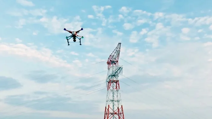
Industrial UAV platforms replace high-risk manual tower climbing with close-range, multi-angle image collection around towers, insulators, fittings, and conductors.
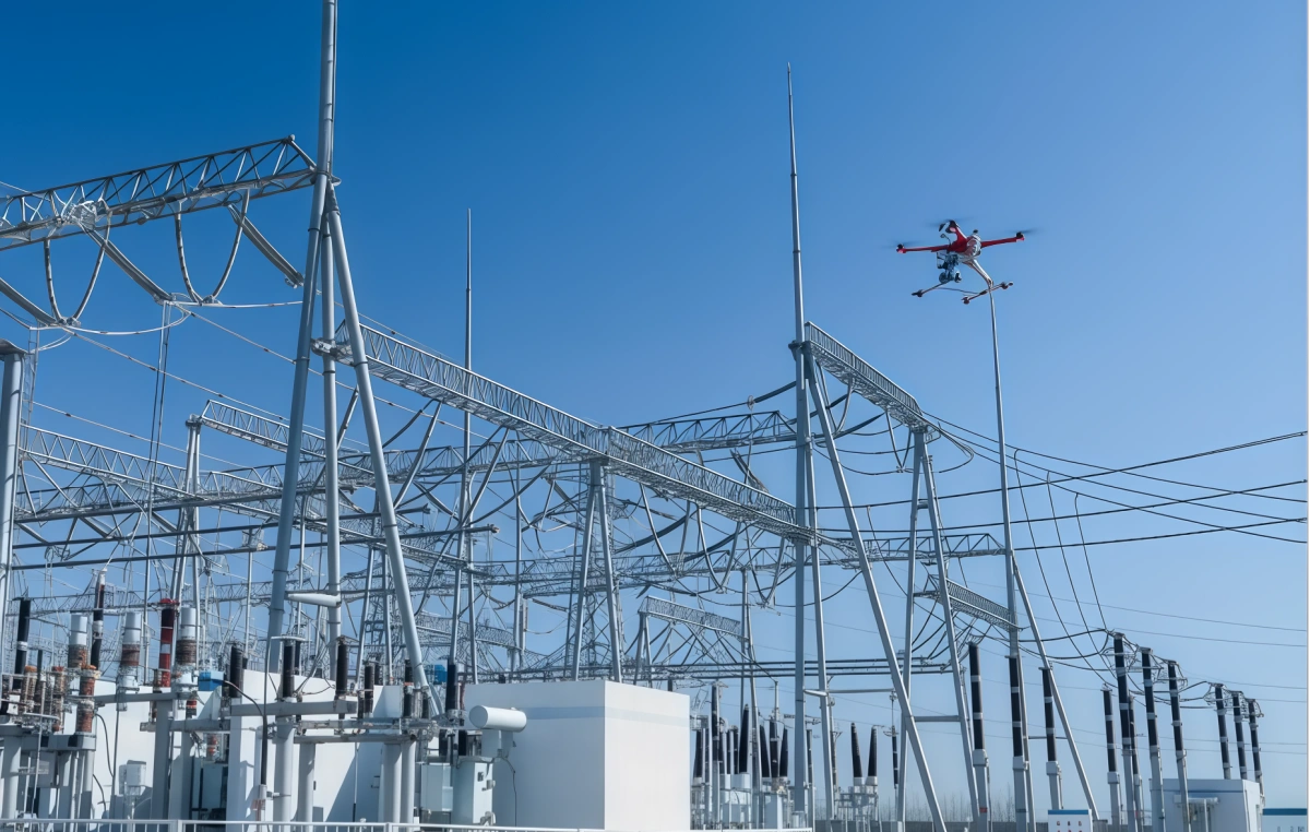
This drone power line inspection solution supports transmission corridor patrol, tower inspection, utility inspection drone operations, and cell tower inspection scenarios for maintenance teams.
A UAV inspection solution built from power-line and tower-inspection operations. It combines industrial UAV platforms, visible-light inspection, thermal infrared detection, LiDAR corridor modeling, AI-assisted defect recognition, and traceable reporting for safer and faster grid maintenance.Industrial UAV platforms replace high-risk manual tower climbing with close-range, multi-angle image collection around towers, insulators, fittings, and conductors.
Visible-light cameras, thermal infrared payloads, and AI recognition support detection of abnormal hot spots, missing or deformed insulators, wire breakage, corrosion, foreign objects, and tower identification details.
Orthophoto, oblique imaging, and LiDAR point-cloud data support corridor modeling, clearance measurement, crossing-distance analysis, and tree-obstruction management.
The solution is organized around field tasks, not around a single UAV model, so operators can combine patrol, monitoring, response, and on-site command operations.
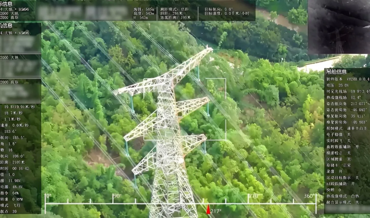
Use tower-inspection UAV imagery to replace manual climbing and capture high-resolution views of tower bodies, insulators, fittings, conductors, and hidden angles.
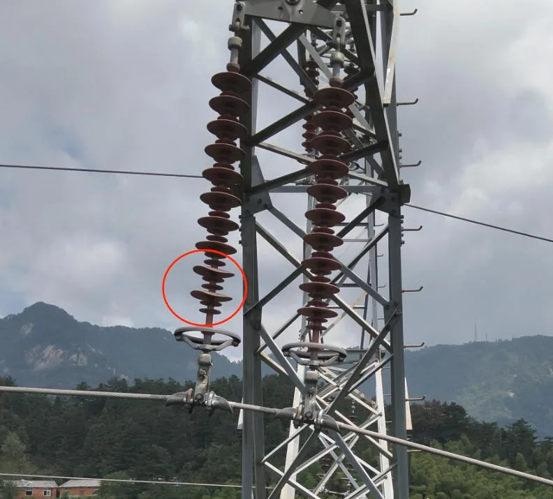
Identify visible defects such as wire breakage, missing or deformed insulators, foreign objects, corrosion, loose hardware, and tower-material markings from high-resolution inspection images.
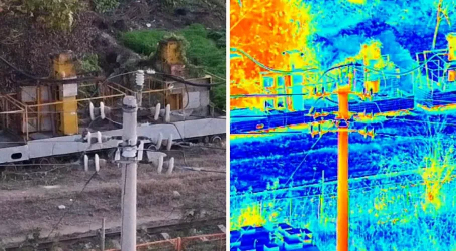
Use thermal infrared imaging to detect abnormal hot spots, overheating equipment, and hidden connection risks that are difficult to confirm through visible-light inspection alone.
Support real-time transmission corridor patrols with orthophoto and oblique imaging, building visual and 3D evidence for terrain, crossing, and route-condition review.
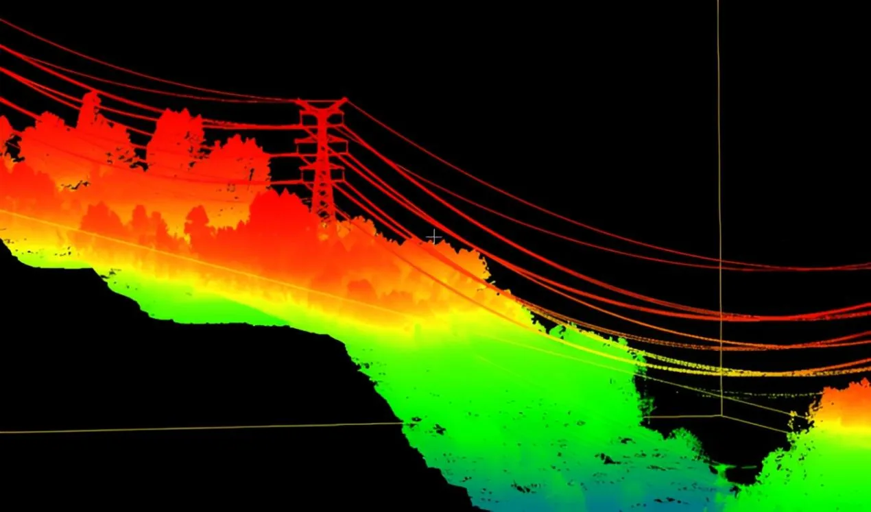
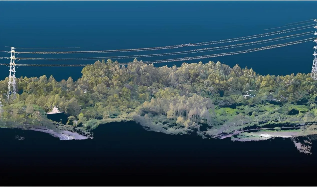
Use LiDAR inspection data to analyze vegetation risks, line-to-ground distance, corridor clearance, and crossing safety margins for clearing and planning decisions.
For drone power line inspection, confirm the operating scenario, payload, communications, endurance, maintenance plan, and related case evidence before selecting equipment.
Before selecting drone power line inspection, the project team should confirm the operating area, mission duration, payload needs, communication conditions, safety requirements, and the data expected by the command or inspection team.
Selection usually compares power line inspection drone, UAV power line inspection, drones for utility inspection, control stations, sensors, data links, power support, and service accessories so field operation stays stable from setup to result review.
Teams should confirm local permissions, operator training, spare parts, maintenance intervals, data handover, acceptance criteria, and the escalation path for field support.
Please fill out the form below, and we can satisfy any of your needs including equipment selection, custom solution design, technical support, or after-sales service. We will contact you as soon as possible.
A UAV inspection solution built from power-line and tower-inspection operations. It combines industrial UAV platforms, visible-light inspection, thermal infrared detection, LiDAR corridor modeling, AI-assisted defect recognition, and traceable reporting for safer and faster grid maintenance.
Power lines and towers are distributed across mountains, forests, river valleys, and wide corridors, so manual patrols require long cycles and expose crews to climbing, height, electric-shock, and weather risks.
Tower components, insulators, fittings, conductors, tower marks, wire breakage, deformation, and abnormal hot spots are difficult to inspect completely from the ground or by manual climbing alone.
Vegetation clearance, crossing distance, terrain conditions, and post-disaster faults need visual, thermal, and 3D evidence that can be archived, reviewed, and assigned to maintenance teams.
Industrial UAV platforms replace high-risk manual tower climbing with close-range, multi-angle image collection around towers, insulators, fittings, and conductors.
Visible-light cameras, thermal infrared payloads, and AI recognition support detection of abnormal hot spots, missing or deformed insulators, wire breakage, corrosion, foreign objects, and tower identification details.
Orthophoto, oblique imaging, and LiDAR point-cloud data support corridor modeling, clearance measurement, crossing-distance analysis, and tree-obstruction management.
Use tower-inspection UAV imagery to replace manual climbing and capture high-resolution views of tower bodies, insulators, fittings, conductors, and hidden angles.
Identify visible defects such as wire breakage, missing or deformed insulators, foreign objects, corrosion, loose hardware, and tower-material markings from high-resolution inspection images.
Use thermal infrared imaging to detect abnormal hot spots, overheating equipment, and hidden connection risks that are difficult to confirm through visible-light inspection alone.
Support real-time transmission corridor patrols with orthophoto and oblique imaging, building visual and 3D evidence for terrain, crossing, and route-condition review.
Use LiDAR inspection data to analyze vegetation risks, line-to-ground distance, corridor clearance, and crossing safety margins for clearing and planning decisions.
For drone power line inspection, confirm the operating scenario, payload, communications, endurance, maintenance plan, and related case evidence before selecting equipment.
Before selecting drone power line inspection, the project team should confirm the operating area, mission duration, payload needs, communication conditions, safety requirements, and the data expected by the command or inspection team.
Selection usually compares power line inspection drone, UAV power line inspection, drones for utility inspection, control stations, sensors, data links, power support, and service accessories so field operation stays stable from setup to result review.
Teams should confirm local permissions, operator training, spare parts, maintenance intervals, data handover, acceptance criteria, and the escalation path for field support.
Please fill out the form below, and we can satisfy any of your needs including equipment selection, custom solution design, technical support, or after-sales service. We will contact you as soon as possible.