Revision editorial y senales de proyecto
Este articulo sobre Power Line Inspection Drone: UAV Operations for Utility Corridors and Transmission Towers fue revisado como una nota de planificacion con 3 puntos: escenario operativo, ajuste de equipos y requisitos de soporte en campo.
Para decisiones de compra, el lector debe comparar la informacion del articulo con paginas de soluciones, fichas de producto, accesorios relacionados y requisitos locales de operacion.
Power line inspection drones are becoming practical tools for utilities that need repeatable evidence from long transmission corridors, towers, conductors, insulators, fittings, and substation equipment. A drone does not replace engineering judgment. Its value is in reaching difficult viewpoints, collecting consistent visual and thermal records, and helping maintenance teams decide which assets need close review, repair planning, or follow-up patrol.
For N-TET, the power-line inspection plan is built around three operating patterns: long-corridor inspection with VTOL UAVs, close-range tower and component inspection with industrial multirotor UAVs, and unattended substation patrol with dock-based autonomous systems. Each pattern has different endurance, payload, data-link, and reporting requirements, so the right system should be selected by inspection route, asset type, payload weight, terrain, and review process rather than aircraft size alone.
What is a power line inspection drone?
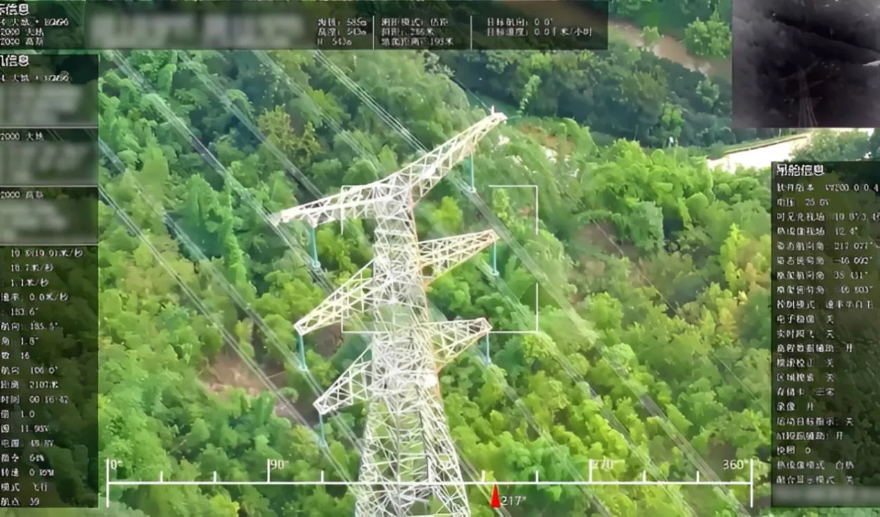
A power line inspection drone is an industrial UAV configured to inspect transmission corridors, towers, conductors, insulators, fittings, and nearby vegetation without requiring every viewpoint to be checked from the ground or by tower climbing. In utility operations, the drone follows planned routes or close-range inspection points, captures visible-light images, thermal infrared data, and in some cases LiDAR or point-cloud evidence, then sends the records to inspection software for defect review and reporting. The strongest use cases are long corridor patrols, tower component checks, thermal hotspot detection, clearance measurement, vegetation encroachment review, and post-storm fault inspection. N-TET?s power-line inspection stack combines VTOL corridor UAVs, tower inspection UAVs, thermal/visible payloads, AI-assisted recognition, and report generation. Human engineers still need to confirm critical findings, set safe flight boundaries, and decide maintenance actions based on utility rules and field conditions.
Why utilities use drones for power line inspection
Utilities usually adopt drone inspection for three practical reasons: safer access, better evidence, and shorter inspection cycles. Transmission corridors often cross mountains, forests, river valleys, roads, and construction areas. Ground crews can miss hidden angles, while tower climbing and helicopter patrol both require higher planning effort and risk controls.
A UAV gives the inspection team a controlled way to collect repeatable images from conductors, insulator strings, tower bodies, fittings, vibration dampers, route corridors, and surrounding vegetation. Thermal payloads help identify abnormal heating that is difficult to confirm with visible-light images alone. LiDAR or 3D modeling can support clearance measurement and tree-obstruction analysis where the maintenance question is not only what the asset looks like, but also how close an object is and where it is located.
The real value is not the flight itself. It is the chain from route planning to evidence capture, defect filing, report output, and maintenance assignment.
Power line drone inspection process
| Step | What happens | Buyer questions to ask |
|---|---|---|
| Route planning | Define corridor, tower points, inspection altitude, camera angles, payload mode, and return route. | Can the platform resume from breakpoint? Can it handle mountain or forest corridors? |
| Field data capture | Collect visible-light images, thermal data, video, and optional LiDAR or point-cloud records. | Which payloads are supported? What payload weight and endurance remain after installation? |
| Defect review | Review wire damage, loose fittings, deformed or missing parts, insulator issues, foreign objects, corrosion, and abnormal hotspots. | Is AI recognition onboard, cloud-based, or manual review only? |
| Corridor analysis | Check vegetation, crossing distance, terrain, and route environment. | Is LiDAR or 3D modeling required for clearance decisions? |
| Reporting | Archive images, temperature records, location data, defect tags, and maintenance recommendations. | Can reports match the utility?s work-order process? |
Which UAV platform fits each inspection task?
Not every power-line inspection task should use the same aircraft. Long corridors need endurance and operating radius. Tower detail checks need stable close-range imaging. Substations need repeatability, docking, and fast task turnaround.
| Inspection task | Better-fit platform | N-TET evidence |
|---|---|---|
| Long transmission corridor patrol | VTOL fixed-wing UAV | The Power Grid Inspection Drone supports VTOL, pure electric power, up to 240 min no-load endurance, 50 km effective operating radius, 10 kg payload, and GPS/Beidou positioning. |
| Tower body, insulator, fitting, and conductor inspection | Industrial multirotor or tower inspection UAV | The Power Tower Inspection UAV supports visible-light and thermal infrared payloads, onboard AI analysis, 4G/5G data transmission, IP55 protection, Level 6 wind resistance, and more than 7 kg payload. |
| Thermal anomaly checks | UAV with thermal infrared payload | N-TET power-line and tower operations include thermal hotspot detection and temperature evidence for equipment review. |
| Vegetation and clearance analysis | UAV with LiDAR or 3D modeling process | The Power Line UAV Intelligent Inspection solution includes LiDAR tree-obstruction analysis, clearance measurement, corridor imaging, and 3D modeling. |
| Unattended substation patrol | Dock-based autonomous UAV system | The Smart Substation Autonomous UAV Inspection System includes automated dock operation, dual-light payload, AI recognition, 4G/5G link, automatic battery swap, and a second mission interval of no more than 5 min. |
Payload selection: visible-light, thermal infrared, and LiDAR
Visible-light imaging is the baseline. It supports tower overview, conductor checks, insulator surface review, fitting condition, label reading, and visible foreign-object evidence. It is also easier for human reviewers to validate than derived sensor outputs.
Thermal infrared is useful when the maintenance risk is heat-related. Overheating connection points, abnormal temperature differences, and hidden electrical risks may not be obvious from ordinary imagery. Thermal data should be captured with consistent distance, angle, and environmental notes; otherwise, the report can create false confidence.
LiDAR is not a universal replacement for visual inspection. It is strongest when the task involves geometry: corridor modeling, clearance measurement, vegetation encroachment, terrain, and crossing-distance analysis. For many utilities, the best inspection stack is layered evidence: visible-light records for component condition, thermal data for heat anomalies, and LiDAR or 3D data for corridor decisions.
What should a utility inspection report include?
A useful drone inspection report should be built for maintenance action, not just image storage. At minimum, it should connect each finding to asset location, tower or span, image/time record, payload type, reviewer judgment, severity level, and recommended follow-up.
For routine patrol, the report can group findings by corridor, tower, defect type, and urgency. For post-disaster fault inspection, it should make route status and access constraints visible quickly. For vegetation and clearance work, it should include measurement evidence, route maps, and comparison points when available.
AI-assisted defect recognition can speed up review, but it should not be presented as final engineering authority. Human confirmation is still needed for high-risk maintenance decisions, especially where weather, image angle, electromagnetic environment, or occlusion affects the evidence.
N-TET system fit: corridor, tower, and substation inspection
N-TET?s current product and solution set supports a utility inspection structure with three connected layers. The Power Line UAV Intelligent Inspection solution is the operating layer. It covers transmission-line patrol, tower component inspection, visible-light defect recognition, thermal hotspot detection, corridor imaging, 3D modeling, LiDAR tree-obstruction analysis, clearance measurement, and post-disaster fault inspection.
The Power Grid Inspection Drone fits long corridors and difficult terrain where VTOL operation, endurance, operating radius, and payload capacity matter. Its published parameters include up to 240 min no-load endurance, 50 km effective operating radius, 10 kg payload, Level 6 wind resistance, and operation from -20 C to 50 C.
The Power Tower Inspection UAV fits closer tower and component inspection. Its evidence profile is more about industrial protection, stable close-range inspection, visible-light/thermal payloads, AI-assisted defect recognition, and real-time 4G/5G transmission.
The Smart Substation Unattended UAV Inspection solution extends the same maintenance logic into substations, with scheduled patrol, dual-light inspection, infrared temperature measurement, AI defect recognition, data archiving, and work-order closure.
Deployment checklist before procurement
- Define route type: long corridor, tower close inspection, substation patrol, post-disaster inspection, or vegetation and clearance survey.
- Confirm payload requirements: visible-light zoom, thermal infrared, LiDAR, multi-sensor gimbal, or data link.
- Check operating constraints: temperature, wind, terrain, electromagnetic environment, battery turnaround, and launch/landing space.
- Confirm endurance after payload installation, not only no-load endurance.
- Decide review model: manual review, AI-assisted recognition, or integrated work-order process.
- Define report format before the first mission.
- Confirm training, spare parts, maintenance, and software handover.
FAQ
Are drones suitable for all power line inspections?
No. Drones are strongest for visual evidence, thermal inspection, route patrol, tower close inspection, and corridor modeling. They still require safe flight planning, trained operators, payload selection, and human review of critical findings.
When should a utility choose a VTOL UAV?
A VTOL UAV is useful when the inspection route is long, launch space is limited, and the mission needs fixed-wing endurance without a runway. It is usually a better fit for transmission corridors than for very close component inspection.
When is a tower inspection UAV better?
A tower inspection UAV is better for close-range imaging of towers, conductors, insulators, fittings, and hidden angles. It should support stable hovering, visible-light and thermal payloads, reliable data transmission, and safe operation near complex structures.
Does LiDAR replace thermal or visual inspection?
No. LiDAR supports geometric questions such as clearance, vegetation encroachment, corridor modeling, and terrain analysis. Thermal imaging supports heat-related findings, while visible-light inspection supports component review and human verification.
What makes a drone inspection report useful?
A useful report links every finding to location, time, image or sensor evidence, asset name, severity, reviewer notes, and maintenance action. For utility teams, the report should support repeat inspection and comparison over time.