
N-TET

Inside N-TET: How We Review Site Photos Before a C-UAS Layout
Published Reviewed by N-TET C-UAS Engineering Team
Inside N-TET: How We Review Site Photos Before a C-UAS Layout

For infrastructure, airport, energy, port, and public-event projects, the first useful engineering material is often not a specification sheet. It is a set of ordinary site photos: rooflines, entrances, fence sections, open areas, control rooms, nearby roads, power points, and places where an operator can safely install or maintain equipment.

Photos reveal what maps can miss

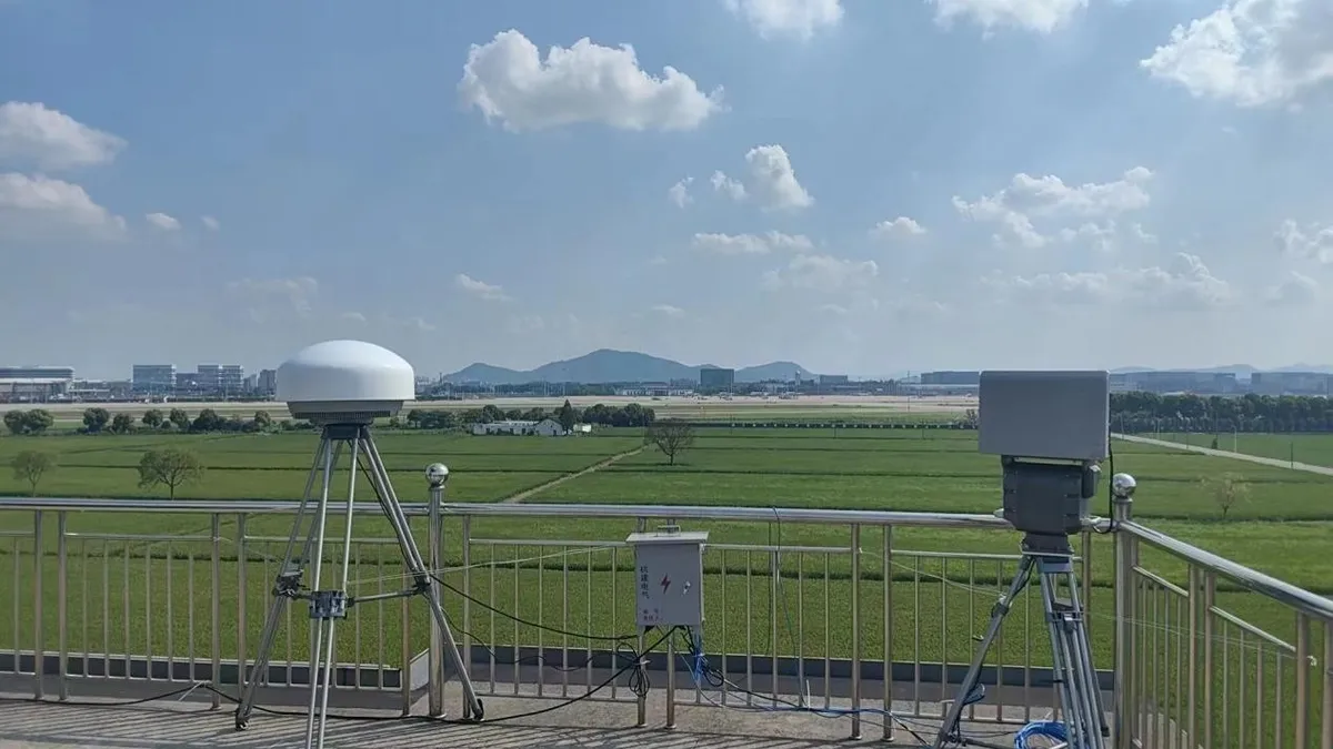
N-TET reviews photos for line of sight, mounting height, cable path, blind corners, glare, terrain shielding, traffic flow, and access for maintenance. A high sensor position may look good on a drawing but fail if there is no safe access, stable power, or realistic route for data backhaul.

Photos also help separate different sensing tasks. RF sensing may need a cleaner electromagnetic environment. Radar needs a view that reduces clutter from buildings, machinery, birds, rain, or moving vehicles. EO/IR confirmation depends on optical line of sight, lighting, weather, and whether an operator can review the image quickly.

How photos support C-UAS layout decisions

A practical layout should explain where low-altitude activity may approach, where blind zones remain, and how alerts move from sensor to operator review. When site photos are available, the proposal can show why a fixed sensor, mobile unit, elevated camera, or Remote ID receiver is placed in a particular position.

This review does not replace a field survey. It improves the first discussion, helps buyers understand assumptions, and reduces the risk of recommending equipment before the operating environment is clear.

Useful photos to prepare

  • Wide views of the site boundary, key assets, and open low-altitude approach areas.
  • Roof, tower, fence, and gate locations where equipment may be mounted.
  • Control-room, guard-room, or command-post locations where alerts may be reviewed.
  • Existing cameras, network cabinets, power sources, poles, cable trays, and access routes.
  • Known problem areas such as glare, water reflection, terrain shielding, or heavy vehicle movement.

With these materials, N-TET can give a more realistic C-UAS layout discussion: what can be monitored, what needs confirmation, what remains uncertain, and what should be checked during commissioning.

Get Expert Drone Defense Advice

Tell us the equipment, application or site you are reviewing. Our team can provide product information, technical documents, pricing and configuration support.

Step 1 of 2

Tell us about your project

*Deployment type

A short note is enough.

MEDIA
Home/Media/Inside N-TET: How We Review Site Photos Before a C-UAS Layout
Inside N-TET: How We Review Site Photos Before a C-UAS Layout
Published · Reviewed by N-TET C-UAS Engineering Team
Inside N-TET: How We Review Site Photos Before a C-UAS Layout

For infrastructure, airport, energy, port, and public-event projects, the first useful engineering material is often not a specification sheet. It is a set of ordinary site photos: rooflines, entrances, fence sections, open areas, control rooms, nearby roads, power points, and places where an operator can safely install or maintain equipment.

Photos reveal what maps can miss

N-TET reviews photos for line of sight, mounting height, cable path, blind corners, glare, terrain shielding, traffic flow, and access for maintenance. A high sensor position may look good on a drawing but fail if there is no safe access, stable power, or realistic route for data backhaul.

Photos also help separate different sensing tasks. RF sensing may need a cleaner electromagnetic environment. Radar needs a view that reduces clutter from buildings, machinery, birds, rain, or moving vehicles. EO/IR confirmation depends on optical line of sight, lighting, weather, and whether an operator can review the image quickly.

How photos support C-UAS layout decisions

A practical layout should explain where low-altitude activity may approach, where blind zones remain, and how alerts move from sensor to operator review. When site photos are available, the proposal can show why a fixed sensor, mobile unit, elevated camera, or Remote ID receiver is placed in a particular position.

This review does not replace a field survey. It improves the first discussion, helps buyers understand assumptions, and reduces the risk of recommending equipment before the operating environment is clear.

Useful photos to prepare

  • Wide views of the site boundary, key assets, and open low-altitude approach areas.
  • Roof, tower, fence, and gate locations where equipment may be mounted.
  • Control-room, guard-room, or command-post locations where alerts may be reviewed.
  • Existing cameras, network cabinets, power sources, poles, cable trays, and access routes.
  • Known problem areas such as glare, water reflection, terrain shielding, or heavy vehicle movement.

With these materials, N-TET can give a more realistic C-UAS layout discussion: what can be monitored, what needs confirmation, what remains uncertain, and what should be checked during commissioning.

Get Expert Drone Defense Advice

Tell us the equipment, application or site you are reviewing. Our team can provide product information, technical documents, pricing and configuration support.

Step 1 of 2

Tell us about your project

*Deployment type

A short note is enough.

WhatsApp