Wide perimeter early warning
Maintain tracks across planned approach sectors before a target reaches the core area.

Compare Ku-band and X-band radar options for early warning, target tracking and handoff to RF and EO/IR confirmation around critical sites.
Drone detection radar provides movement, range, bearing, altitude, speed and continuous track data without depending on a recognizable radio-control link or cooperative identity broadcast. It supports wide-area early warning, multi-target tracking and automatic cueing of EO/IR or RF sensors. Target radar cross-section, flight altitude, route, terrain, buildings, vegetation, weather, clutter, scan geometry, mounting height and close-in blind zones all affect usable coverage. Ku-band and X-band options also differ in reference range, elevation coverage, blind zone and track capacity, so selection should follow a site drawing and coverage simulation rather than the band name alone. In an integrated C-UAS workflow, radar tracks are correlated with RF or Remote ID data, handed to EO/IR for visual confirmation and displayed on the command platform for coordinated response.
Maintain tracks across planned approach sectors before a target reaches the core area.
Add movement evidence when a recognizable RF or Remote ID source is unavailable.
Pass track position to visual systems for operator confirmation where line of sight permits.
Send standardized track data to a shared platform for status and handoff.
Compare the stated specifications as a starting point; final coverage remains a site-engineering question.
A DBF radar for 360° low-altitude search, track generation and multi-sensor platform integration.
A 3D pulse-Doppler radar for 360° search, target tracking, alert review and event records.
These values describe product test conditions, not guaranteed site coverage.
| Selection factor | Ku-band radar | X-band radar |
|---|---|---|
| Reference range | ≥5 km at RCS 0.01 m² | ≥10 km Phantom 4; ≥7 km egret at stated false-alarm condition |
| Close-in blind zone | ≤150 m | ≤200 m |
| Coverage | 360° azimuth; ≥60° pitch | 360° azimuth; 0–30° pitch |
| Track capacity | ≥500 tracks | ≥200 tracks |
| Data / interface | 2-second data rate | UDP over Gigabit Ethernet |
A usable radar track moves through evidence correlation, operator confirmation and a defined handoff to the responsible site team.
Radar searches the planned sector and creates a track with time, range, bearing, altitude or speed fields supported by the configuration.
The platform compares the track with RF, Remote ID, permitted-flight and map context.
EO/IR cueing and operator review add visual evidence and a review status.
The command platform correlates the confirmed track, presents sensor and device status, coordinates the configured response sequence, and records alarms, commands and outcomes for review.
Define escalation contacts, decision authority, site procedures and record-retention requirements before commissioning.
Radar placement and confirmation workflow change with the site geometry and operating team.
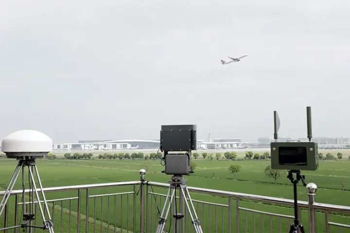
Radar tracks support early warning around approach routes and boundary zones, then cue RF and EO review before command-room escalation.
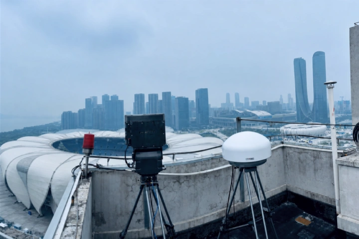
A temporary radar and RF layout supports event-area awareness, mobile team coordination and a defined escalation path.
No. Detectability depends on target characteristics, route, altitude, terrain, clutter, weather, scan geometry and mounting. Coverage should be reviewed against the real site.
Compare the stated range condition, blind zone, elevation coverage, target capacity, interface, mounting and the sectors that matter at the site—not the band label alone.
Radar contributes movement and track data; RF can add signal or identity clues; EO/IR can add visual confirmation. Correlation gives the operator a more reviewable event.
The platform maintains the correlated track, presents the target and device status, coordinates the configured response sequence and records the complete event.
Tell us the equipment, application or site you are reviewing. Our team can provide product information, technical documents, pricing and configuration support.
Tell us the equipment, application or site you are reviewing. Our team can provide product information, technical documents, pricing and configuration support.