01
A rapidly deployable UAV platform reaches the scene first and sends live video through multi-link communications, helping command centers understand event dynamics in real time.
طائرة البحث والإنقاذ هو موضوع البحث الرئيسي لهذه الصفحة، مع تغطية مرتبطة بـ طائرة بحث وإنقاذ, طائرات حرارية للبحث والإنقاذ, UAV للبحث والإنقاذ.
يُستخدم البحث والإنقاذ والاستطلاع في مواقع الكوارث في مراقبة المجال الجوي وتوثيق الأحداث، مع دعم الدعم الطارئ واستمرارية العمليات وتنسيق فرق التشغيل حسب متطلبات الموقع. يساعد الحل على جمع المعلومات، وتوثيق الأحداث، وتحويل بيانات المراقبة إلى إجراءات قابلة للمراجعة دون كشف تفاصيل تشغيلية حساسة.A rapidly deployable UAV platform reaches the scene first and sends live video through multi-link communications, helping command centers understand event dynamics in real time.
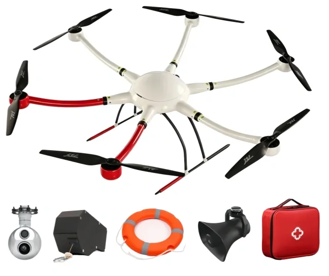
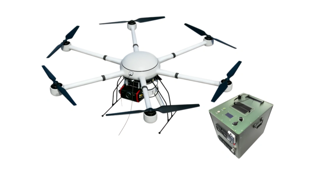
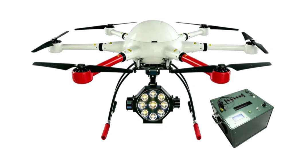
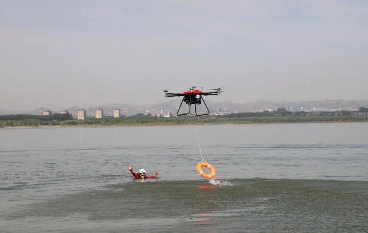
Interchangeable payloads such as HD wide-angle cameras, thermal imaging, gas detection, loudspeaker, and lighting modules cover reconnaissance, monitoring, search support, and on-site coordination.
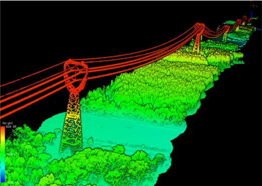
Aerial data can be processed into orthophotos, 3D models, GIS layers, and time-series comparisons, improving disaster assessment, hidden-risk discovery, and post-event review.
The solution follows the emergency process: get eyes on the scene first, map the affected area, identify hazards, and give command teams usable evidence for dispatch and review.
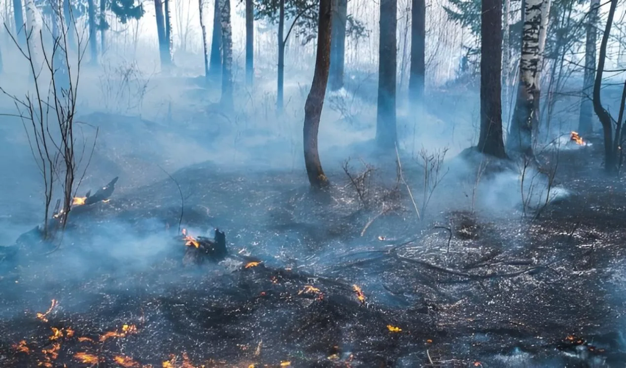
Use rapid aerial patrols and live image transmission to monitor forest fire scenes, incident areas, evacuation routes, and resource deployment status for command decision-making.
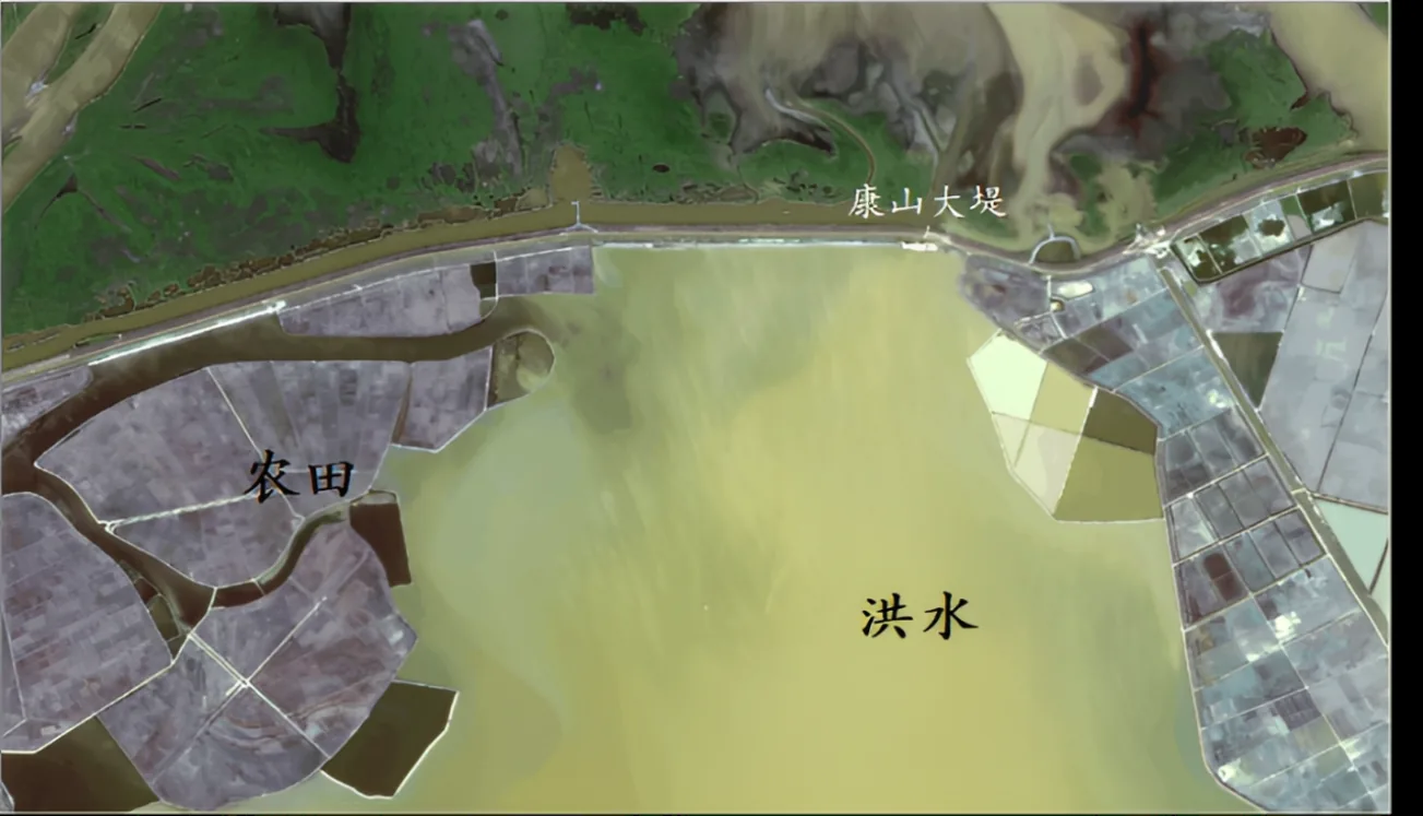
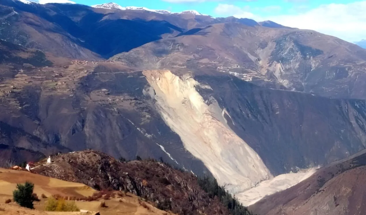
Capture multi-angle imagery of affected areas, generate orthophoto maps and 3D terrain or water-area models, and measure shape, area, volume, excavation, or fill data for response planning.
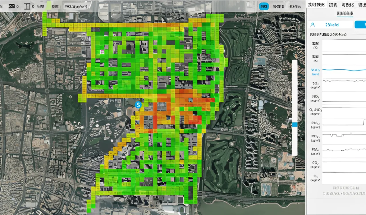
Support aerial inspection of pollution sources, hazardous zones, gas indicators, and industrial incident scenes, giving emergency and enforcement teams traceable visual evidence.
بالنسبة إلى طائرة البحث والإنقاذ، أكد سيناريو التشغيل والحمولة والاتصالات ومدة الطيران وخطة الصيانة وأدلة الحالات ذات الصلة قبل اختيار المعدات.
قبل اختيار طائرة البحث والإنقاذ، يجب على فريق المشروع تأكيد منطقة التشغيل ومدة المهمة واحتياجات الحمولة وظروف الاتصال ومتطلبات السلامة والبيانات المتوقعة من فريق القيادة أو التفتيش.
عادة تقارن عملية الاختيار طائرة بحث وإنقاذ, طائرات حرارية للبحث والإنقاذ, UAV للبحث والإنقاذ، ومحطات التحكم، والمستشعرات، وروابط البيانات، ودعم الطاقة وملحقات الخدمة حتى يبقى سير العمل مستقرا من الإعداد الميداني إلى مراجعة النتائج.
يجب أن تؤكد الفرق التصاريح المحلية وتدريب المشغل وقطع الغيار وفترات الصيانة وتسليم البيانات ومعايير قبول المشروع ومسار التصعيد للدعم الميداني.
يرجى تعبئة النموذج أدناه. سيساعدنا ذلك على فهم احتياجاتك في اختيار المعدات، أو تصميم الحل، أو الدعم الفني، أو خدمة ما بعد البيع، وسيتواصل معك فريقنا في أقرب وقت.
يُستخدم البحث والإنقاذ والاستطلاع في مواقع الكوارث في مراقبة المجال الجوي وتوثيق الأحداث، مع دعم الدعم الطارئ واستمرارية العمليات وتنسيق فرق التشغيل حسب متطلبات الموقع. يساعد الحل على جمع المعلومات، وتوثيق الأحداث، وتحويل بيانات المراقبة إلى إجراءات قابلة للمراجعة دون كشف تفاصيل تشغيلية حساسة.
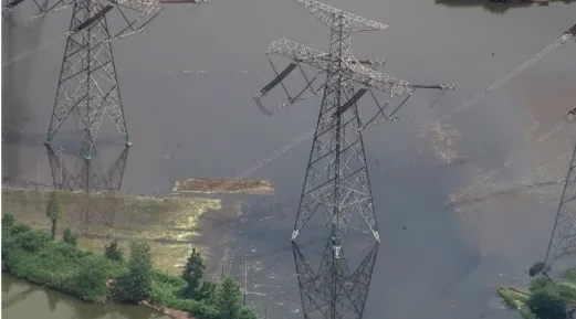
Disaster sites change quickly: roads may be blocked, ground teams may be unable to approach safely, and secondary hazards can expand before command teams have a full view.
Forest fires, landslides, floods, drought impacts, hazardous gas leaks, and polluted industrial areas all require rapid aerial observation, mapping, and evidence capture.
Emergency commanders need live imagery, accurate affected-area measurements, orthophoto or 3D outputs, and clear risk-zone information to dispatch teams with confidence.
A rapidly deployable UAV platform reaches the scene first and sends live video through multi-link communications, helping command centers understand event dynamics in real time.
Interchangeable payloads such as HD wide-angle cameras, thermal imaging, gas detection, loudspeaker, and lighting modules cover reconnaissance, monitoring, search support, and on-site coordination.
Aerial data can be processed into orthophotos, 3D models, GIS layers, and time-series comparisons, improving disaster assessment, hidden-risk discovery, and post-event review.
Use rapid aerial patrols and live image transmission to monitor forest fire scenes, incident areas, evacuation routes, and resource deployment status for command decision-making.
Capture multi-angle imagery of affected areas, generate orthophoto maps and 3D terrain or water-area models, and measure shape, area, volume, excavation, or fill data for response planning.
Support aerial inspection of pollution sources, hazardous zones, gas indicators, and industrial incident scenes, giving emergency and enforcement teams traceable visual evidence.
بالنسبة إلى طائرة البحث والإنقاذ، أكد سيناريو التشغيل والحمولة والاتصالات ومدة الطيران وخطة الصيانة وأدلة الحالات ذات الصلة قبل اختيار المعدات.
قبل اختيار طائرة البحث والإنقاذ، يجب على فريق المشروع تأكيد منطقة التشغيل ومدة المهمة واحتياجات الحمولة وظروف الاتصال ومتطلبات السلامة والبيانات المتوقعة من فريق القيادة أو التفتيش.
عادة تقارن عملية الاختيار طائرة بحث وإنقاذ, طائرات حرارية للبحث والإنقاذ, UAV للبحث والإنقاذ، ومحطات التحكم، والمستشعرات، وروابط البيانات، ودعم الطاقة وملحقات الخدمة حتى يبقى سير العمل مستقرا من الإعداد الميداني إلى مراجعة النتائج.
يجب أن تؤكد الفرق التصاريح المحلية وتدريب المشغل وقطع الغيار وفترات الصيانة وتسليم البيانات ومعايير قبول المشروع ومسار التصعيد للدعم الميداني.
يرجى تعبئة النموذج أدناه. سيساعدنا ذلك على فهم احتياجاتك في اختيار المعدات، أو تصميم الحل، أو الدعم الفني، أو خدمة ما بعد البيع، وسيتواصل معك فريقنا في أقرب وقت.